The Violent Floods that Reshaped the Northwest
FOR ALL RECORDED HISTORY, people in the Northwest have been puzzled by huge geographic features in a region known as the Channeled Scablands. This region is dotted with curiosities: giant waterfalls with no water, humongous boulders dropped in the middle of wheat fields, and massive canyons carved by an unknown water source.
In the 1920s, J Harlen Bretz, a geologist who surveyed this region, had a visionary moment when he realized that these features, as large as they are, could not have been formed by rivers or glaciers but by huge floods. The fact that there was no obvious source for these prehistoric floodwaters led many in the scientific community to view Bretz's theories with doubt and scorn.
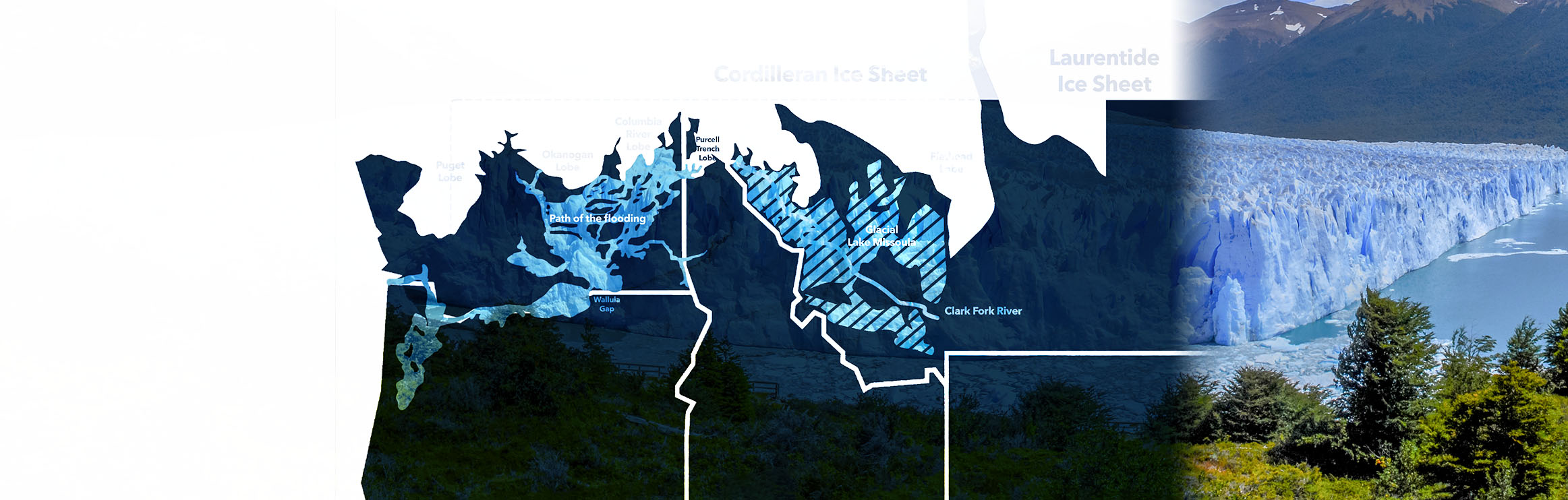
In order to even begin to understand such a huge flood, Bretz had to envision the conditions of the region during the last ice age. Around 2 million years ago, the Earth’s climate changed. Glacial ice sheets as thick as 12,000 feet advanced southward and then retreated. These cycles repeated several times. Most of northwestern North America was covered by the Cordilleran Ice Sheet, which extended south into present day Washington, Idaho and Montana.
In present day North Idaho, one of the lobes of the Cordilleran Ice Sheet would provide Dr. Bretz with his long-sought source of water for the floods. During the last ice age, the Purcell Trench Lobe, extending south from the main ice sheet like greedy fingers, formed an ice dam in the Clark Fork River, blocking the flow and creating Glacial Lake Missoula.
A geologist named Joseph T. Pardee had been studying evidence of a massive lake in the Clark Fork Valley. He documented high-water marks, seemingly out of place, high in the mountains of western Montana. He also found giant ripple marks, similar to a lake shore or beach, on the Camas Prairie.
When all the puzzle pieces gathered by Bretz and Pardee were finally put together, the mystery of the Channeled Scablands was finally solved.
Formed by ice dams on the Clark Fork River, Glacial Lake Missoula stretched more than 200 miles in length and reached depths of 2,000 feet. It held as much water as Lake Erie and Lake Ontario combined. And the evidence suggests that the ice dam may have formed and then ruptured approximately 40 times over the course of 2,000 years.
When the ice dam holding back Glacial Lake Missoula burst, it unleashed a violent torrent of water that raced through Eastern Washington at a speed of up to 80 mph. The entire lake drained in the span of 48 hours. The flood discharge was 13x the volume of the Amazon River.
Within the first hours, the waters spilled east over Idaho and Washington. When they slammed against the Okanogan Lobe, they turned south, carving the features of the Grand Coulee in the process. At Wallula Gap, just southeast of the present-day Tri-Cities, the waters were slowed down and backed up into giant, temporary lakes.
As the incomprehensible amount of water flowed over the land, it carved deep coulees and deeper plunge pools in places where it formed temporary waterfalls. In the process, the mighty floodwaters also scoured the topsoil and carried most of it away in an instant. After the waters passed, the precious loess that had blanketed the region (in some places hundreds of feet deep) was gone.
Or maybe “gone” is the wrong word. More like “moved."
When that rushing water temporarily slowed down behind the Wallula Gap, much of that soil and sediment settled to the bottom and remained there when the water ran off days or weeks later. To this day, those basins are filled with deep and productive silty topsoil. Satellite imagery shows areas of green, productive agricultural land that matches the flood basins almost perfectly.
That productive soil, combined with Washington’s “Goldilocks climate” and the irrigation provided by the Columbia Basin Project have helped to make Eastern Washington into a powerhouse of agricultural production.
AS YOU MIGHT KNOW, most of Eastern Washington is a desert or semi desert climate (specifically a shrub steppe high desert). Most regions receive less than 20” of precipitation, so growing crops is already a challenge. In fact, each region of Eastern Washington has unique challenges to overcome. But despite the challenges, Eastern Washington is one of the most productive agricultural regions in the world.
Much of the productive topsoil, called loess (a fine, mineral-rich topsoil), that was scoured from northeast Washington settled to the bottom of the temporary lakes that formed behind Wallula Gap. Not only did those basins benefit from new soil, but so did the land immediately to the southeast of them.
Once the water drained, prevailing winds of the region reworked this sediment into dunes of loess, blanketing the region southeast of the basin, known now as the Palouse, with meter upon meter of the rich topsoil. The steep hillsides of those dunes always meant harvest was a problem, until farmers developed tilting-head hillside combines.
If you’re familiar with wheat growing, you know that silty loess is an ideal soil for growing wheat. It provides soil aeration and water retention, and it allows for deep roots and easy cultivation. So it shouldn’t surprise you that Whitman County (home of the Palouse) produces more wheat than any other county in the United States.
In some fields in the northern Columbia Basin, farmers have to plant and plow around giant erratics – boulders of granite or basalt that were transported by advancing glacial lobes or rafted on glacial ice during the flooding. Despite the desert climate, the presence of irrigation water from the Columbia River means the land now yields fruit trees, vegetable fields, grains and grasses.
And in the Channeled Scablands, where most of the topsoil was carried away, growing a crop is notoriously difficult. But farmers measure every drop of moisture and fertilizer in order to somehow coax a crop out of the stubborn ground. Wheat and barley fields produce a crop year in and year out.
The Ice Age Floods formed the Pacific Northwest as we know it. Even now, driving throughout Eastern Washington, you can still see their effects. You can probably also see that if farmers weren’t so good at growing their crops, nothing would grow there at all.
